
City of Kodiak & Road System
A busy fishing port with about 100 miles of roads to explore.

Alaska region guide
The Emerald Isle — giant bears, salmon rivers and green coastal peaks.
On the ground
Overview
Kodiak is the largest island in Alaska and the second largest in the United States, at roughly 3,600 square miles. Together with Afognak, Shuyak and dozens of smaller islands it forms the Kodiak Archipelago, lying across Shelikof Strait from the Alaska Peninsula.
The island's interior is a tangle of rugged coastal mountains, deep fjord-like bays and green tundra slopes — so lush in summer that locals call it the Emerald Isle. Most of it lies within the Kodiak National Wildlife Refuge, home to roughly 3,500 Kodiak brown bears, among the largest bears on earth.
The City of Kodiak is one of the busiest fishing ports in the country, and a short road system links it to beaches, rivers and old WWII sites. Beyond the roads, everything is reached by floatplane or boat: remote lodges, refuge cabins, salmon rivers like the Karluk and Ayakulik, and hunting country for deer, goats, elk and bears.
Local guides
Explore
Kodiak brown bears, salmon rivers and a sprawling wild archipelago.
The Emerald Isle — giant bears, salmon rivers and green coastal peaks.
The Emerald Isle — giant bears, salmon rivers and green coastal peaks.
The Emerald Isle — giant bears, salmon rivers and green coastal peaks.
Explore
Ranges and icefields define this region's high country.
A spine of rugged, glacially carved mountains runs down the center of Kodiak Island. Long fjord-like bays — Uyak, Uganik, Kiliuda and others — cut deep into it, so almost no point on the island is far from salt water.
Access: Steep green slopes of grass, alder and tundra above rocky shores; few trees outside the northeast. Weather changes fast.
Koniag Peak (about 4,470 ft, the island's highest) · Pyramid Mountain (2,401 ft, near town) · Barometer Mountain (2,452 ft)
Explore
Local state & national parks options. Check current availability and land-manager advice.
City of Kodiak & Road System
Check the land manager's current visitor information before arranging travel.
Type: state park
Land manager: Alaska State Parks
Permits: Confirm reservations, commercial operator permissions and backcountry requirements with the land manager.
Kodiak National Wildlife Refuge
Check the land manager's current visitor information before arranging travel.
Type: refuge
Land manager: US Fish and Wildlife Service
Permits: Confirm reservations, commercial operator permissions and backcountry requirements with the land manager.
Afognak & Shuyak Islands
Check the land manager's current visitor information before arranging travel.
Type: state park
Land manager: Alaska State Parks
Permits: Confirm reservations, commercial operator permissions and backcountry requirements with the land manager.
Content coming soon
Explore
Established trails and backcountry routes offer very different levels of commitment.
Steep, open climb with views across the archipelago.
Anton Larsen Pass on the road system
Trail detailsRelentlessly steep local favorite with big views over town and the bays.
Near the airport, off Chiniak Highway
Trail detailsSpruce forest, WWII bunkers and sea cliffs.
Fort Abercrombie State Historical Park
Trail detailsExplore
Species, waters and approximate monthly run timing. Always check current fishing regulations and emergency orders.
The refuge's most famous river, with king, sockeye, silver and steelhead runs; reached by floatplane.
Sockeye salmon · King salmon · Silver salmon · Pink salmon · Chum salmon · Steelhead · Pacific halibut
River
Remote southwestern river with strong king, sockeye and silver runs.
Sockeye salmon · King salmon · Silver salmon · Pink salmon · Chum salmon · Steelhead · Pacific halibut
River
Road-accessible salmon fishing near town.
Sockeye salmon · King salmon · Silver salmon · Pink salmon · Chum salmon · Steelhead · Pacific halibut
River
Halibut, lingcod, rockfish and salmon charters out of Kodiak harbor.
Sockeye salmon · King salmon · Silver salmon · Pink salmon · Chum salmon · Steelhead · Pacific halibut
Saltwater
On the water
| Season | Jan | Feb | Mar | Apr | May | Jun | Jul | Aug | Sep | Oct | Nov | Dec |
|---|---|---|---|---|---|---|---|---|---|---|---|---|
| King / Chinook | ||||||||||||
| Sockeye / Red | ||||||||||||
| Coho / Silver | ||||||||||||
| Pink / Humpy | ||||||||||||
| Chum / Dog |
Approximate freshwater timing varies by river and year. Pink runs can vary with odd/even years. A run does not mean fishing is open; check current regulations and emergency orders.
A field companion
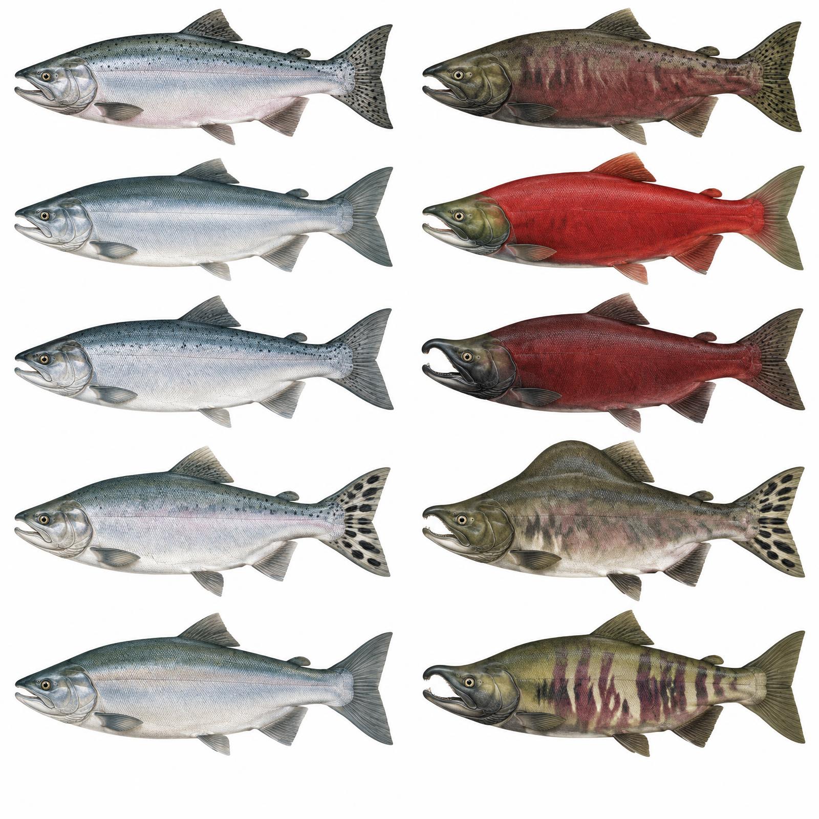
King
Usually 10–20 lb
Red
About 4–8 lb
Silver
Usually 8–12 lb
Humpy
Average 3.5–5 lb
Dog / Keta
About 6–12 lb
Illustrations are interpretive; identify fish by several traits together, not pupil shape alone. Adult sizes vary by stock. Official ADF&G identification chart
Current ADF&G sport-fishing regulations and emergency orders
Explore
Steep coastal mountains, alder thickets and open alpine slopes; access is by floatplane or boat.
Brown bear hunts are by draw permit in spring and fall, and nonresidents must hunt with a licensed guide. Deer seasons run late summer into winter; goats and elk are mostly permit hunts in the fall.
Game management unit: 8
Nonresidents: Nonresidents hunting brown/grizzly bear, Dall sheep or mountain goat need a licensed Alaska guide or an eligible Alaska-resident relative; nonresident aliens require a guide for all big game. Check current permits, seasons and emergency orders.
Kodiak brown bear (limited draw permits) · Sitka black-tailed deer · Mountain goat · Roosevelt elk (Afognak & Raspberry islands)
Seasons, permits and land restrictions change. Check current Alaska Department of Fish and Game regulations before planning a hunt.
Explore
Coastal and inland wildlife reward patient, responsible viewing.
Observe from a safe distance and respect feeding and travel routes.
Observe from a safe distance and respect feeding and travel routes.
Observe from a safe distance and respect feeding and travel routes.
Observe from a safe distance and respect feeding and travel routes.
Observe from a safe distance and respect feeding and travel routes.
Bear country
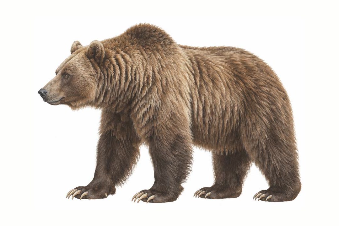
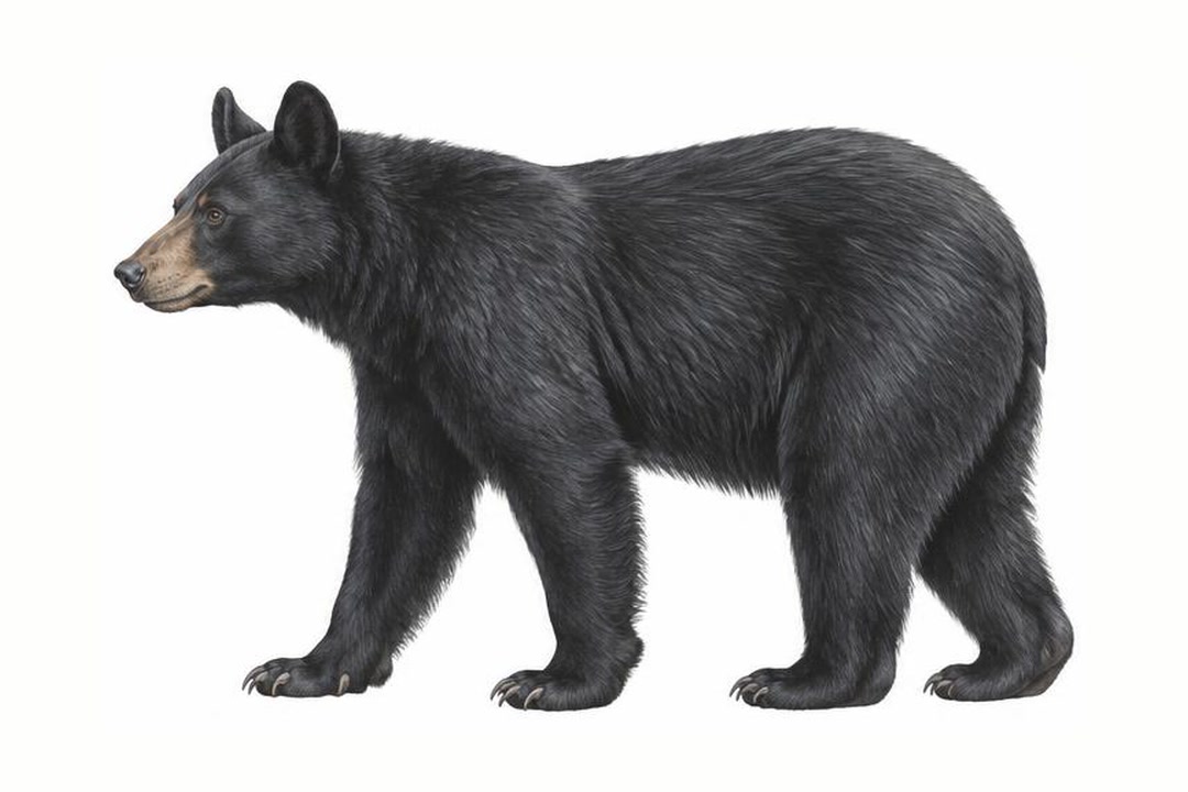
Both species vary in coat color. Never approach a bear to identify it. Stay alert, make noise in dense cover, give bears space, secure food and garbage, and never run. Carry accessible bear spray and know how to use it.
ADF&G bear safety guidanceExplore
Local four-wheel drive & backroads options. Check current availability and land-manager advice.
City of Kodiak & Road System
Chiniak and Pasagshak roads; check surfaces and access.
Conditions: Verify seasonal openings, washouts and land permissions.
Vehicle: Check rental exclusions; do not enter uncertain water crossings.
Kodiak National Wildlife Refuge
No road access to remote refuge areas.
Conditions: Verify seasonal openings, washouts and land permissions.
Vehicle: Check rental exclusions; do not enter uncertain water crossings.
Afognak & Shuyak Islands
Afognak logging roads require landowner access; Shuyak has no public road system.
Conditions: Verify seasonal openings, washouts and land permissions.
Vehicle: Check rental exclusions; do not enter uncertain water crossings.
Content coming soon
Explore
Local rafting & paddling options. Check current availability and land-manager advice.
City of Kodiak & Road System
Protected bays near town; check tides and exposure
Difficulty: Reach- and weather-dependent; obtain local advice
Season: Generally summer; verify water levels, ice and operator schedules
Kodiak National Wildlife Refuge
Karluk River float trips; arrange flights and bear-safe camps
Difficulty: Reach- and weather-dependent; obtain local advice
Season: Generally summer; verify water levels, ice and operator schedules
Afognak & Shuyak Islands
Shuyak channels kayaking; strong tides outside protected bays
Difficulty: Reach- and weather-dependent; obtain local advice
Season: Generally summer; verify water levels, ice and operator schedules
Content coming soon
Explore
Local camping options. Check current availability and land-manager advice.
City of Kodiak & Road System
Facilities and seasons vary; pack out waste and store food securely away from wildlife.
Kodiak National Wildlife Refuge
Facilities and seasons vary; pack out waste and store food securely away from wildlife.
Afognak & Shuyak Islands
Facilities and seasons vary; pack out waste and store food securely away from wildlife.
Content coming soon
Explore
Local other activities options. Check current availability and land-manager advice.
City of Kodiak & Road System
Confirm availability directly, and respect community guidance and access permissions.
Kodiak National Wildlife Refuge
Confirm availability directly, and respect community guidance and access permissions.
Afognak & Shuyak Islands
Confirm availability directly, and respect community guidance and access permissions.
Stormy, quiet
Winter halibut lull
Deer & eagles
Spring bear permits
Bears emerge, kings arrive
Sockeye & green hills
Peak bear viewing & salmon
Pinks & silvers begin
Silver salmon, fall hunts
Steelhead, deer hunting
Late steelhead
Dark & windy
Content coming soon
Through the year
| Season | Jan | Feb | Mar | Apr | May | Jun | Jul | Aug | Sep | Oct | Nov | Dec |
|---|---|---|---|---|---|---|---|---|---|---|---|---|
| Wildlife viewing | ||||||||||||
| Fishing | ||||||||||||
| Hiking | ||||||||||||
| Northern lights | ||||||||||||
| Midnight sun | ||||||||||||
| Winter sports |
Peak and shoulder planning windows; weather and conditions vary. Aurora requires darkness and clear skies. Southern Alaska has long summer days, not a true 24-hour midnight sun.
Explore
Getting there and around.
Daily flights from Anchorage to Kodiak (ADQ), about an hour.
The Alaska Marine Highway runs from Homer to Kodiak, roughly a 10-hour crossing.
About 100 miles of roads radiate from the city; rental cars available.
Floatplane operators fly from Trident Basin and Lilly Lake into the refuge, lodges and cabins.
Charter boats reach coves, cabins and hunting areas around the archipelago.
Anchorage
jet · About 1 hour
Kodiak
Homer
ferry · About 10–14 hours; sailing varies
Kodiak
Kodiak
floatplane · About 30–60 minutes; destination varies
Refuge lakes
Typical travel estimates, not a timetable. Check operators and allow time for weather.
Gallery